
 Using MapBallsGPS for ATV Trails
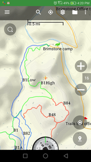
We provide ATV trail maps to be used with various gps devices including Android and Apple phones and tablets. We have spent a lot of time researching different apps and devices out there as well as recording all of the trails in our maps and just wanted to share some of our knowledge. We believe having the trail maps available via GPS device is an incredibly valuable tool but, we also recommend carrying a paper map at all times in case device(s) should become disabled/drained, etc. it is also nice to be able to stretch out a large paper map and take a much wider view of what might be around instead of trying to scroll around on even a 10” tablet screen. The concept of GPS mapping for ATV trails is foreign to a lot of folks and they are expecting it to work like google maps or the navigation in their car telling them a turn is coming up in 100 ft. That technology is coming, more and more app companies are starting to handle offroad turn by turn navigation. We notice some companies claiming they have “navigate to” – we are not really sure what that means – obviously, they are not willing to stand up and say “turn by turn” so, the description of “navigate to” is rather elusive at the moment. Our idea was to provide the maps and allow our customers to use their own device so they didn’t have the expense of another device as well as having to buy another case and keep track of another power cord etc. It just makes it more economical and easier for them. By doing this, our customers also get the benefit of being able to choose an app that suites their needs instead of being stuck with what we provide them. This offers several advantages. It keeps their cost down (The premier app for Android right now is $11.99. There is a trial version of it for free with somewhat limited functionality and, there are several free apps out there.) If they damage or lose their device, it wasn’t an expensive single use device and, they did not lose our maps. We take care of our customers not the device we sold them. If they decide to upgrade, same thing – we take care of our customers. They don’t have to worry about syncing their music from one device to another, or any other things that may need synced. Most people already have a protective case for their phone/ tablet and some mounting mechanism. If not, you probably should anyway. If they are using a phone or cellular tablet, we do not use the data plan and we do not need cell signal/minutes but, our customers have the option of making/receiving calls. As well as the apps we recommend have the capability to send a text/email that includes your exact coordinates to friends, family or rescue workers if needed. (This only works if you have some internet connection) We have reviewed several apps(Paid and free) for both operating systems. We are happy to make a recommendation but, the only requirement for using our ATV trail maps is that the app you choose is capable of importing gpx files. We have noticed that some do a better job of importing than others and some do a better job of following standards than others. We have seen some that will import but do not handle trail colors correctly or waypoint icons correctly. We will cover apps in another blog entry. The way we use and expect most folks use GPS maps for ATV Trails is that the maps are loaded on the device so the trails show up on top of a traditional map, you tell the app to locate to your current position, it shows a pointer where you are and much like your car, that pointer follows you along moving either the background map or the pointer so you can tell what your current location is and what is around you. We add “Waypoints” or Points Of Interest to our maps as well. We try to show waterfalls, interesting overlooks, caves, mines but, we also add the campgrounds and their information like phone numbers, recovery numbers, places to eat or get gas or the vet just in case Muffy is having a bad day traveling. There are several different views available to you through most of the apps that we recommend. You can use satellite view, street view, any of several topographical views with varying degrees of detail. We have found that for offroad by ATV/Jeep, a lot of detail isn’t really necessary. The USGS topo maps frequently go down to the level of marking houses, gravel pits, etc. and most of that isn’t very necessary but, it is nice to know creeks, railroad tracks, rough terrain so, we recommend either Thunder forest or our own custom background map. Choosing a device Some devices (just a few tablets mainly) do not have gps sensors in them – if you are considering purchasing one for this use, make sure to check the specs for gps. If you already own one, you can try to look it up online or you can install a gps app and see if it connects and locates correctly. We like the Samsung Galaxy line but, we have also used Ipad, IPad Air, some off brand android tablets and several other devices – most work fine. Accuracy Our maps are typically very accurate. There will be some discrepancies based on the weather conditions not only the day we recorded them but also the day you are using them. As well as accuracy of your device (normally within 30 ft or so), Typically, we are within 50-60 feet and that is certainly close enough to see the trail or landmark you are looking for. Planning a ride The apps we recommend also give you a way to plan your rides. You can use one of several methods to create a “route” usually by either tracing trails on the screen or touching points on the screen. Then, you can just follow your route without having to think ahead about trail number and which way to turn. Riding around places other than where you have purchased maps. The apps we recommend also allow you to record your own trails either in the areas we offer or at other places. It is easy to add to an existing trail set or create a new one. Some things customers have noted are The map screen may be twitchy at times – especially when sitting still or moving very slowly. This should clear up as soon as you start moving more than 1 or 2 miles per hour. This is typically caused by vibration of your machine or poor satellite reception. GPS devices receive signals from satellites hundreds of miles above the earth and calculate position based on the time it takes those signals to arrive in relation to signals from the other satellites. They do this thousands of times a minute. If you are not moving, there isn’t very much change in the time it takes the signals to arrive so, your device has a difficult time telling if you moved or not. It may pivot or swing the map. Again, this is because of the tiny amount of movement associated with sitting still or vibration – it is having a hard time telling if you turned or not. Weather and/or surroundings effect this as well. If it is cloudy or you are sitting under a tree, it will be more likely to happen. When you are deciding to start into using a gps device for ATV trail maps, here are some things to consider. What areas do you plan to ride? What is your budget? Do you need a separate device or do you already have one? Do you have space for another device? Do you want to pay extra money for trails that you will never need? We offer you the opportunity to buy just the trails you need, using your own device and not pay a lot of extra money for extra stuff that you will never use. If you have comments or questions, please post them in the comments section and we will do our best to answer or help. Thank you, Scott and Kay Ball MapballsGPS ATV Trail Maps
0 Comments
Your comment will be posted after it is approved.
Leave a Reply. |
AuthorScott and Kay Ball Archives
March 2019
Categories |
 RSS Feed